| Home Travel Index | First Posted: Oct 13, 2009 Jan 21, 2020 | |
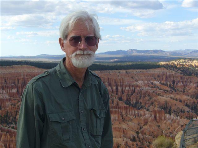
Grand Canyon (North Rim), Bryce and Zion National Parks via Las VegasBill and I have been many places around the globe. Each one is unique and a treasure to enjoy, however, the Grand Canyon's north rim, Bryce and Zion are a National treasure that should not be missed.
Las Vegas
Our gateway was Las Vegas where we stayed for two days. We flew United Airlines on air miles. Upon arrival we picked up an AVIS rental car at the airport and proceeded to the hotel. Our hotel was the Bellagio. The Bellagio is a 5 star hotel and has comfortable accommodations. There are a number of sister hotels such as the MGM, the Excaliber, the Mirage, and others. If you go to Vegas and are able to take in a show you might consider "O," Cirque du Soleil. The show is excellent--full of dashing displays of color, technical feats, and unique acts. We are so happy that we purchased tickets. I would also like to mention an excellent restaurant at the Bellagio Complex. We had a exquisite dinner at Michael Mina's. Service, food and wines were excellent. You cannot go wrong! On the way back from our trip we stayed at the Mirage. I made our reservations on the Internet by booking a room in advance. I kept checking back and found that the room charges changed often. I re booked at the Mirage and saved over $50.00 a night for exactly the same room. There is no penalty for changing your booking if the same room price changes. On our last night of the trip we met some lovely family from California and Las Vegas and had dinner at Tommy Bahama's Restaurant which is located in the Town Center going out toward the airport. It was excellent. I am happy to say that we did not gamble, but rather enjoyed the sighs and sounds. People watching is also a favorite in Las Vegas. Heavy smokers, drinkers and gamblers abound!
Grand Canyon (North Rim)
   Drama Over the Grand Canyon (North Rim)
It takes about 4 1/2 hours to drive from Las Vegas to the North Rim of the Grand Canyon. It is a pleasant drive. Along the way the scenery was varied and beautiful. Our lodging at the north rim was at the North Rim Lodge a room (not a cabin) which is not actually in the lodge. You eat in the lodge, hear ranger programs, etc. at the lodge--but do not stay "at the lodge." Everything is well run. It is very user friendly. Make your reservations for dinner in advance if you want a specific time to eat. There is also the Deli in the Pines in the Grand Canyon North Rim Complex, the Roughrider Saloon, the Coffee Saloon and a Grand Canyon Cookout Experience that is offered. Camping is also available in the North Rim Park and outside the park at DeMotte Campground, Jacob Lake Campground, and dispersed camping in the Kaibab National Forest. A gas station is on the access road to the North Rim. Inquire at the Lodge about any services that you need. Grand Canyon North Rim Lodge Accommodations
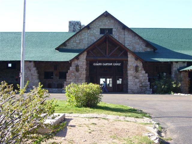 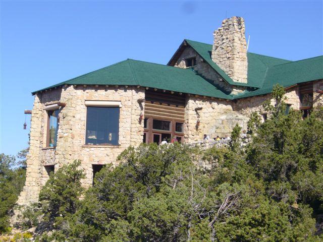 Grand Canyon Lodge on the North Rim of the Grand Canyon is often the first prominent feature that you see, even before viewing the canyon. The highway ends at the lodge. The lodge's sloped roof, huge ponderosa beams and massive limestone facade fit its 8,000 foot setting, but where is the Grand Canyon? To experience the full impact of the design of the lodge, take the historic route. Go through the front entrance. Walk across the carpeted lobby and descent a stairwell. Shining through great windows across the "Sun Room" is the much-anticipated first view of the Grand Canyon. The architect, Gilbert Stanley Underwood, following the wishes of then Director of the National Park Service, Steven Mather, designed a rustic national park lodge. The Grand Canyon Lodge served as a symbol of the importance of the preservation of this natural wonder, while allowing for luxury and enjoyment. Yet, Underwood had incorporated something extra - a surprise view! Underwood'sd 1928 Grand Canyon Loge, designed for then-concessionaire the Union Pacific Railroad, is not today's lodge. Underwood's design included a massive Spanish-style exterior with a high front topped by an observation tower. The original burned down in 1932 and a "new" 1937 lodge sits on its footprint. The fire that destroyed the 1928 lodge spread from below the kitchen to engulf the structure within minutes. On the top floor over the auditorium slept the only inhabitants-the lodge manager, his wife, and the maids. All exited safely to stand watching helplessly in the early morning hours, of September 1, 1932. The...nearby cabins, except two, escaped the blaze. The Utah Parks Company, Union Pacific's subsidiary, hastily erected a cafeteria and recreation hall. The next summer the buses brought more visitors, but Underwood's secret surprise of having your first view of the Grand Canyon inside the lodge, was lost until the summer of 1937. That June, the Grand Canyon Lodge reopened. Utilizing the same floor plan, the builders had erected a more sensible structure with sloped roofs, better able to shed the heavy snows. They also preserved Underwood's surprise view. The Lodge still exhibits Underwood's genius. Another genius, the geologist Clarence E. Dutton, came to the North Rim in 1880 and described his experience in his masterpiece, A Tertiary History of the Grand Canyon District. "The earth suddenly sinks at our feet to illimitable depths. In an instant, in the twinkling of an eye, the...scene is before us..." About the North Rim of the Grand Canyon
Sitting atop the Kaibab Plateau 8,000 feet above sea level with lush green meadows surrounded by a mixed conifer forest sprinkled with white-barked aspen, the North Rim is an oasis in the desert. Here you may observe deer feeding or coyote chasing mice in the meadows, a mother turkey leading her young across the road, or a mountain lion slinking off into the cover of the forest. We saw condor which were almost extinct several years ago. They measure 6 feet in wing span--what a sight to see as they ride the wind currents and soar gracefully and swiftly. Bill and I did some hiking. We want to warn you that you may be affected by the altitude. If you think that it would be fairly simple to hike 3/4 of a mile down and 3/4 of a mile back in 30 minutes--think again. We took the North Kaibab Trail. The distance of hiking time varies. It is the only maintained trail into the canyon from the North Rim. Even this short hike was difficult. Going down is hard on your joints, coming up is hard aerobically. The air is light and your heart beats rapidly. We are in relatively good shape and had to drink lots of water and rest often. That short hike dropped 800 feet into the canyon! The mules use the same trail! Beware. Hiking Tips
Health Hazards
Moderation is the key to having an enjoyable hike. Hike within your ability, maintain proper body temperature, balance your food and water intake, and rest often.
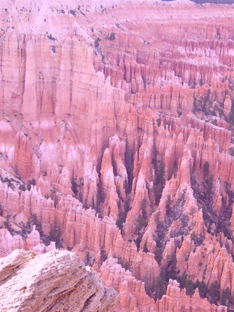
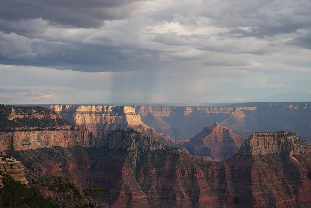
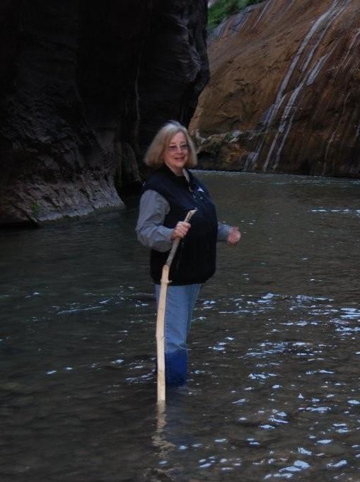
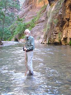
NOTE: An interesting fact to know is that the Grand Canyon gets the second most lightning strikes of any place in the United States. Tampa, Florida gets the most lightning strikes in the United States. We could see the lightning striking the South Rim as we watched from the viewing area outside the Lodge. The clouds and rain could be seen in specific areas along the rim and then the lightning. It was quite beautiful. On the second evening at the North Rim a gentleman had is telescope set up. The lights were turned out and he showed us the Milky Way, a nebula and Jupiter and three of its moons. The sky was a mass of stars, so clear, so bright, so beautiful. Only one other place have seen such a sky and that was in Tasmania. There was one major difference, however, in Tasmania the stars are completely different, no Big Dipper, no Orion, etc. An entirely new field! Source: The above information was taken from the 2009 North Rim Visitor's Guide handed out at the Ranger Station as you enter The North Rim of the Grand Canyon. BryceFrom there we drove to Bryce which only takes a few hours. There is a wonderful store, the Red Canyon Indian Store, which is located 34 miles east of US 89 on Highway 12, 15 miles from Bryce Canyon National Park. It has an excellent array of Indian jewelry, Navajo rugs, Tee shirts, moccasins, pottery, western wear, rocks and fossils and Indian arts and crafts in the southwest. We purchased several necklaces and some pottery as gifts. Ask for Maybelle (Many Mules). She is wonderfully helpful. The store is seasonal due to weather in the area. It is usually open from late March or April to October, however, you should call and check to see. You can reach Many Mules at (435) 676-8160. If you want to order anything during their closed period you can do so by contacting her. Their mailing address is P.O. Box 410, Panguitch, Utah 84759. There is also a good restaurant called the Cafe Adobe which is on the same highway. It has a lovely outdoor patio and indoor seating as well. The cuisine is varied. We ordered really good Mexican food, quite different than the normal fare. In Bryce we stayed at Rudy's Inn which I would not stay in ever again! BIG MISTAKE. It was a total zoo and an enormous tourist trap! I would stay in the Bryce Canyon Pines, instead. It is run by locals and is tasteful and pleasant. As you can see below, we took the mules to see Bryce. Bill and I took the half day trip. There were two horses (I am on one of them) and the rest were mules. I suggest that you take a mule as they are more sure-footed. My horse, Taquila, was new to the circuit. He was very well mannered and sweet, however, very ouchy on his front feet. In fact, he went down on his right knee at one point. Bill was behind me and saw this. We were at the end of the line. The drop is quite far down--so get a mule! Being in the back we also ate a lot of dust. Our guide was hard to hear and not very informative, however, the view from the mules was excellent. None of this really mattered. I would do it again anytime. Bill's mule, Alaska, was fine, but on automatic pilot. He lagged behind going down hill and ran to catch up going up hill. He was the last one in line. He was also sure footed. I would like to note that even though we ride all the time at home, the Western saddles were as hard as boards with little, if any, padding. Bill's rubbed a sore and mine left me a present, too. We asked how long the animals lasted on this gig and were told approximately 4 years for mules, less for horses. I would not want to do it! Our horses, A Patchy and Rusty Man really have it cushy!!! 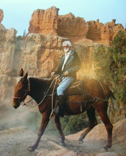 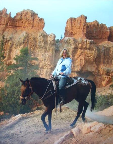 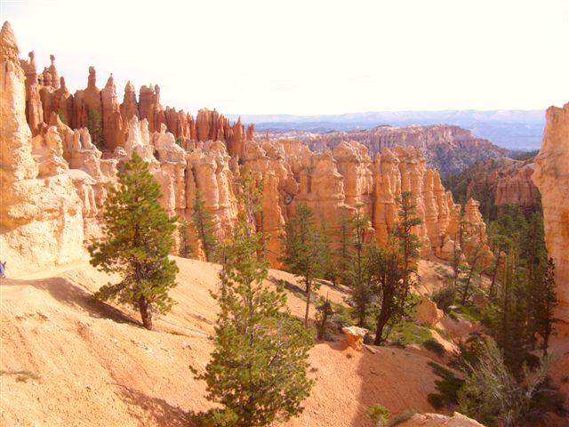 The above rock formations are called hoodoos. The geographic history at Bryce Canyon National Park is rich and complex. Many processes and events have interacted over vast amounts of time to create and continually alter this unique landscape. The story begins long before technicolor hoodoos emerged from this limestone that geologists call the Claron Formation. First, you need to lithify sediments-turn them to rock. Before lithifying sediments, you need to trap them in a basin. To build a basin you need to first build mountains. Approximately (-) 200 million years ago (Ma), Earth's crust was crinkling throughout Nevada, into southern Canada. A strong, dense Pacific sea floor had smashed into North America's weaker continental crust. Much was at stake as the loser would be forced down and melted in Earth's mantle. Although North America remained on top, it was shattered in the contest. Over the 120 million year match, compressional forces bent, folded, broke, and heaved our crust into the sky, giving birth to the once mighty Sevier Mountains. Given enough time, rain and snow become geologic jackhammers splitting mountains apart. From the mountains, streams and rivers debris was carried eastward, pulverizing the boulders to mud in transit. Slightly before the dinosaurs went extinct, -65 Ma, the land in the Western U.S. changed dramatically. Down but not out, the oceanic plate pushed up our continental crust, stubbornly surfing atop the mantle instead of sinking and melting. This attempt at escaping uplifted land, forming the Rocky Mountains and warping Utah and Arizona. The continued slow uplift shaped a land-locked basin between the Silver Mountains and the younger Rockies. When the rivers wearing down the Sevier Mountains reached this basin they became braided streams and deposited layers of muds and silts. At the lowest levels, chains of lakes and ponds formed. Water escaped through evaporation, but with no rivers flowing out of the basin, the sediment was trapped. Between 55 - 30 Ma this mammoth mud puddle, known as the Claron Basin, continued to fill with sediments rich in calcium carbonate-dissolved limestone. The Claron Formation consists of two types of limestone rock. It has a lower pink member and an upper white member. In the early years of the basin, the environment appears to have been more marsh-like, where plant roots helped oxidize iron to give the sediments a red color. Within the pink member, thin and non-continuous gray layers formed, suggesting that individual ponds within this marsh setting became so salty and/or mineralized that only cyanobacteria could survive. These algal-like creatures enriched limestone with magnesium they took from the water to create dolostone - important to hoodoo formation. With the passage of time and an increase in water depth, the basin transitioned into purer lakes where the less iron-rich white limestone was deposited. Geologists are unsure as to this mud puddle's fate as rocks that might have recorded this story do not exist. Did it evaporate away? Was it eventually drained as the basin was uplifted? What geologists are sure of is that over time these beds of sediment were compressed into rock and uplifted from 3000 feet to 9000 feet in elevation. This uplift began -15 Ma, forming the Colorado Plateau. About 8 Ma, the Bryce Canyon area broke off this uplift as the Paunsaugunt Plateau and has been sinking ever since into the Great Basin. Technically, Bryce is not a canyon because canyons are primarily carved by flowing water - a stream or a river. Naturally acidic rainwater dissolves limestone, making the rounded edges of hoodoos, but the freezing and thawing of water does most of the sculpting at Bryce Canyon. Approximately 200 days a year, ice and snow melt during the day and refreeze at night. When water becomes ice, it not only gets harder but expands to -110% its original volume! This exerts enormous pressures on the rocks, forcing them apart from inside the cracks. First attacking the fractures created during uplift and faulting, the rock is chiseled into broken remains Monsoon rains remove this debris, helping to reveal fins, the first step in hoodoo creation. Most commonly, the second step in hoodoo formation begins when frost-wedging cracks the fins, making holes in call windows. When windows collapse they create the rust painted pinnacles we call hoodoos. We often think of this process as hoodoo creation; when, in reality, it's just another step in water's endless process of destroying the rocks it began creating 55 Ma. Five other rock formations exist in the park. They tell stories of dinosaurs, beaches, and of a sea that once separated North America into two large islands. Source: The above information was taken from the "The Hoodoo" handed out as you enter the Bryce Park. It is put out by the National Park Service, US Department of the Interior. From Bryce we continued on to Zion which took only 2 hours. In Zion we stayed at the Cliffrose Lodge and Gardens which we highly recommend. We had room number 31 which had a lovely balcony and magnificent view. Although not inside the park it is a quick, easy WALK--or catch the shuttle bus right in front of the lodge. The receptionist, Stephanie, was a delight and very helpful. Cafe Soleil is right next to Cliffrose Lodge and has excellent sandwiches and breakfast foods, as well. You can eat inside, outside or take your meal out. We ate a lovely breakfast from Cafe Soleil on our balcony at the Cliffrose. For dinner we ate at the Spotted Dog Café. It was outstanding and we would highly recommend it. The Bit and Spur was another excellent dining experience. Their menu was varied. Bill and I had Mexican food, and I might add, some of the best we have ever eaten. Although hard to believe, there was a lightness to it! Bill and I try to eat smaller portions and these restaurants allowed us to share our entree. Many restaurants have a problem with that or will charge you an extra plating fee. They had no problem with it, nor did they charge a plating fee.  Stephanie
 Zion National Park Cliffrose Hotel view from our balcony. Room Number 31.
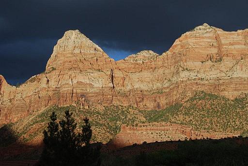
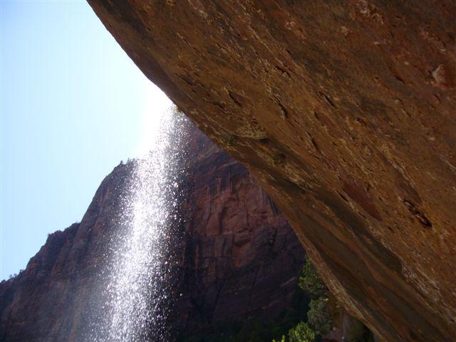
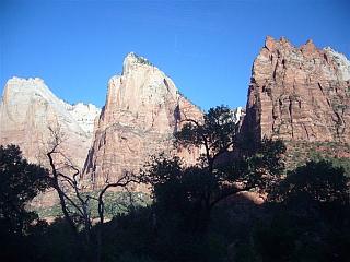
 The following pictures give you an idea of the varied beauty of Zion:
     About Zion
Bill and I were amazed at how smoothly everything at Zion National Park worked. The planning to make the park user friendly for visitors was outstanding. The shuttles ran constantly, (just make sure you are on the right one, i.e., into park or into town), the trails were beautifully maintained and easy to navigate, the park was clean, the restaurants were excellent, everything you could want or need was at your fingertips. Zion National Park is Utah's First National Park. Massive canyon walls ascend toward a brilliant blue sky. To experience Zion, you need to walk among the towering cliffs, or challenge your courage in a small narrow canyon. These unique sandstone cliffs range in color from cream, to pink, to red. They could be described as sand castles crowning desert canyons. Necessary Info on Your Stay At Zion Almost 12,000 years ago Zion's first peoples, who are now almost invisible, tracked mammoth, giant sloth, and camel across southern Utah. Due to climate change and over hunting these animals died out about 8,000 years ago. Humans adapted by focusing on mid-sized animals and gathered foods. As resources dwindled 2,600 years ago, people tuned lifeways to the specifics of place. Such a culture, centered on Zion, differentiated over the next 1,500 years into a farming tradition archaeologists call Virgin Anasazi. Zion's geology provided these and later pioneer farmers a combination rare in the desert: a wide, level place to grow food, a river to water it, and an adequate growing season. On the Colorado Plateau crops grow best between 5,000 and 7,000 feet, making Zion's elevations -- 3,666 to 8,726 feet -- almost ideal. Differences in elevation also encourage diverse plants and animals; mule deer and turkey wander forested plateaus; bighorn sheep and juniper prosper in canyons. The Anasazi moved southeast 800 years ago, due probably to drought and overuse. Soon after, Paiute peoples brought a lifeway fine-tuned to desert seasons and thrived. In the 1860's, just after settlement by Mormon pioneers, John Wesley Powell visited Zion on the first scientific exploration of southern Utah. By hard work and faith pioneers endured in a landscape that hardly warranted such persistence. Flash floods destroyed towns and drought burned the crops. Only the will to survive saw Paiute, Anasazi, and European descendants through great difficulties. Perhaps today Zion is again a sanctuary, a place of life and hope. Geologic Formations of ZionMammals of Zion Birds of Zion Reptiles and Amphibians of Zion Plants of Zion Located on the Colorado Plateau, but bordering the Basin and Range Province, Zion is home to plants from both regions. Sedimentation, uplift, and erosion have resulted in elevations ranging from 3600 to 8700 feet. The unique geology of massive cliff walls has created such diverse environments as: deserts, canyons, slickrock (smooth wind-polished rock), hanging gardens, riparian, and high plateaus. With its wide variety of habitats, Zion has one of the most diverse groupings of plants in Utah, with over 900 species. |