Travel Israel Continued
by Debora Johnson
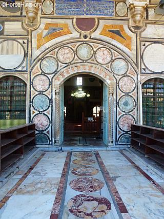
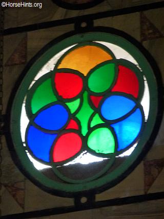
One of the treasures that is often missed is the Tunesian Djerba Synagogue. My friend, Nomi, who is an Israeli living in Virginia, told us to make sure to see it. This synagogue is the only one of its kind in the world. We asked Graeme to take us and he did. He, too, had not been inside. All four stories, within and without, display spectacular mosaics (from Kibbutz Eilon). The synagogue's stained glass windows and its mosaics, created from hundreds of millions of natural stones, all from Israel, recount the history of the Jewish People and of the Land of Israel through Biblical stories, fauna and flora.
Tunesian Djerba Synagogue
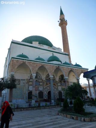
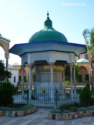
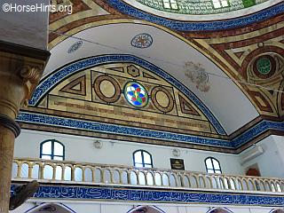
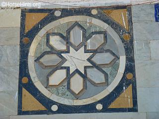
El-Jazzar Mosque,  also known as the White Mosque, in Arabic 'Jama El Basha' (the Mosque of the Pasha) and formerly also 'Jama El Anwar' (The Mosque of Lights) is the largest mosque in Israel outside Jerusalem and the largest mosque built in Israel during the Ottoman period. El-Jazzar Mosque is also considered the most important Mosque in Akko as well as the most elaborate. According to the inscription over the entrance, the mosque was consecrated in 1781/82 AD, early in the rule of Ahmed el-Jazzar in Akko. El-Jazzar Mosque is named after its builder, Ahmed al-Jazzar. Jazzar was the ruler of the north of Israel on behalf of the Ottoman Empire at the end of the eighteenth century. He was nicknamed "The Butcher" because of his cruelty. In order to build the Mosque, al-Jazzar brought specialists from Greece and Cyprus and used parts of the ancient structures of Caesarea and Atlit. also known as the White Mosque, in Arabic 'Jama El Basha' (the Mosque of the Pasha) and formerly also 'Jama El Anwar' (The Mosque of Lights) is the largest mosque in Israel outside Jerusalem and the largest mosque built in Israel during the Ottoman period. El-Jazzar Mosque is also considered the most important Mosque in Akko as well as the most elaborate. According to the inscription over the entrance, the mosque was consecrated in 1781/82 AD, early in the rule of Ahmed el-Jazzar in Akko. El-Jazzar Mosque is named after its builder, Ahmed al-Jazzar. Jazzar was the ruler of the north of Israel on behalf of the Ottoman Empire at the end of the eighteenth century. He was nicknamed "The Butcher" because of his cruelty. In order to build the Mosque, al-Jazzar brought specialists from Greece and Cyprus and used parts of the ancient structures of Caesarea and Atlit.
We also visited the Galilee and saw sites that were most important to the Galilee Ministry of Jesus. We entered an old synagogue which was small and full of books. We went to Tzefat (Safed). Safed is considered by the Jewish people as a city of mysticism and as the city of Kabbalah
. "...Kabbalah's definition varies according to the tradition and aims of those following it, from its religious origin as an integral part of Judaism, to its later Christian, New Age, and Occultist syncretic adaptations. Kabbalah is a set of esoteric teachings meant to explain the relationship between an unchanging, eternal, and mysterious Ein Sof (no end) and the mortal and finite universe (God's creation). While it is heavily used by some denominations, it is not a religious denomination in itself. It forms the foundations of mystical religious interpretation. Kabbalah seeks to define the nature of the universe and the human being, the nature and purpose of existence, and various other ontological questions. It also presents methods to aid understanding of these concepts and thereby attain spiritual realization. Kabbalah originally developed entirely within the realm of Jewish thought, and kabbalists often use classical Jewish sources to explain and demonstrate its esoteric teachings. These teachings are held by followers in Judaism to define the inner meaning of both the Hebrew Bible and traditional Rabbinic literature and their formerly concealed transmitted dimension, as well as to explain the significance of Jewish religious observances. Traditional practitioners believe its earliest origins pre-date world religions, forming the primordial blueprint for Creation's philosophies, religions, sciences, arts, and political systems. Historically, Kabbalah emerged, after earlier forms of Jewish mysticism, in 12th-to 13th-century Southern France and Spain, becoming reinterpreted in the Jewish mystical renaissance of 16th-century Ottoman Palestine. It was popularized in the form of Hasidic Judaism from the 18th century onwards. 20th-century interest in Kabbalah has inspired cross-denominational Jewish renewal and contributed to wider non-Jewish contemporary spirituality, as well as engaging its flourishing emergence and historical re-emphasis through newly established academic investigation."
During the 2,000 years of exile when Jews lived abroad, outside of the land of Israel, there remained within the borders of the land a few special cities where a minority community of Jews continued to live, work and study. Safed was one of these continuously populated cities...Much of life in the Jewish areas of Safed revolved around the synagogue and for this reason there are many synagogues, both ancient and modern, within the city. Although Safed has been ravaged by earthquakes throughout the centuries, most of these synagogues have survived and many of them have mysterious legends surrounding their ability to withstand the devastating earthquakes.
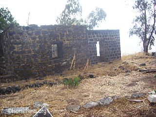
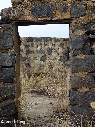
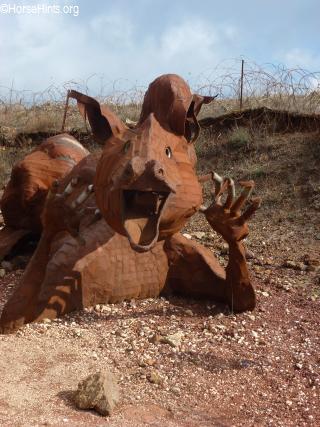
Another one of Graeme's sparkles was Kafr Bir'im, Kafar Bir'em and Kfar Bar'am. I have done a separate article on this experience as it goes to the heart of much of the political strife in the Middle East. Kafr Bir'im, Kafar Bir'em, Kefr Berem and Kfar Bar'am
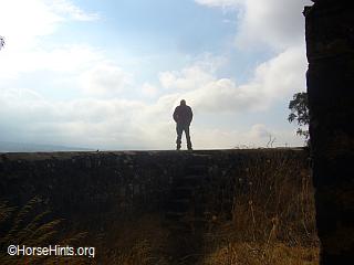
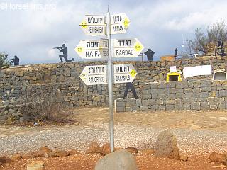
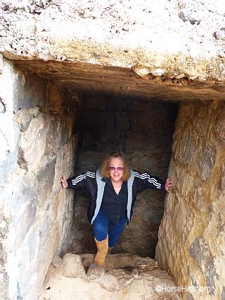
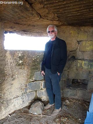
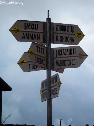
Golan Heights, Har Bental where the army bunkers are located and a panoramic view at the crossroads of three countries, Jordan River Valley, Jerusalem, Welcome Shabbat with Rabbi for dinner.
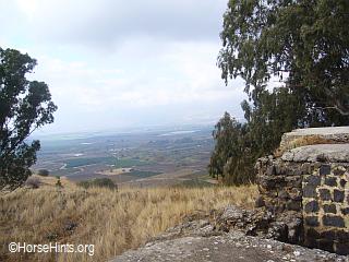
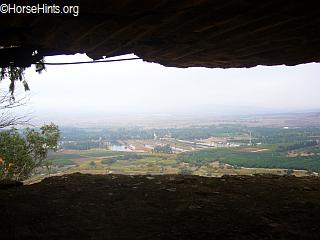
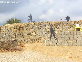
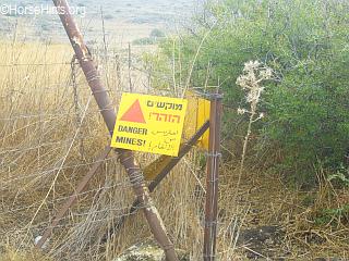
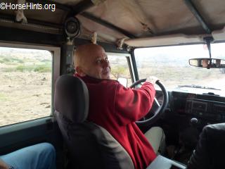
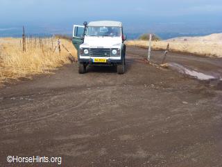
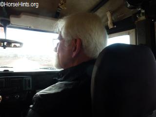
Golan Heights, Har Bental: We could look down from Mount Bental and see Mount Hermon, the Golan and to the east--Syria. Damascus is approximately 60 km away. The Yom Kippur War of 1973 was fought at this site. Mount Bental is considered a key strategic point for Israel because of its high location. There were more than 1,500 tanks and 1,000 artillery pieces that Syria used to attack. The Israel's had only 100 Army tanks. Israel was reduced to 7 tanks in this battle, but took out 600 Syrian tanks in the process. Israel took heavy casualties but eventually the Syrians retreated. The area between Mount Bental and Mount Hermon is known as the Valley of Tears. It was here that we went with Graeme and his guide, friend, in a Land Rover, to retrace this battle. We saw the bunkers, trenches, border and area that is still land mined. Both these guides served in the military and could recount vivid memories of the war. Remember, too that the Golan Heights is a strategic position for water rights, as well.

High ground in Golan looking down. This is where the 1,500 Syrian tanks assembled and attacked. Taken with telephoto. More sparkle from Graeme. We are so glad that Graeme took us to see this. It was really quite interesting. "Muslims believe that the grave of Moses is located at Maqam El-Nabi Musa which lies 11 km (6.8 mi) south of Jericho and 20 km (12 mi) east of Jerusalem in the Judean wilderness. A side road to the right of the main Jerusalem-Jericho road, about 2 km (1.2 mi) beyond the sign indicating sea level, leads to the site. The Fatimid, Taiyabi and Dawoodi Bohra sects also believe in the same. In contrast, the biblical book of Deuteronomy records that Moses was buried "in the valley in the land of Moab opposite Beth-peor" (east of the Jordan River) and that "no one knows the place of his burial to this day". The site of Nabi Musa is a convenient stop for travelers and pilgrims associated with the festival though, and the identification as Moses' tomb infuses the site with meaning, even if it is not historically accurate..." Nabi Musa Mosque

Mount of Beatitudes
The Mount of Beatitudes (Hebrew: Har HaSimcha) refers to a hill in northern Israel where Jesus is believed to have delivered the Sermon on the Mount.
Location: The traditional location for the Mount of Beatitudes is on the northwestern shore of the Sea of Galilee, between Capernaum and Gennesaret (Ginosar). The actual location of the Sermon on the Mount is not certain, but the present site (also known as Mount Eremos) has been commemorated for more than 1600 years. The site is very near Tabgha. Other suggested locations have included the nearby Mount Arbel, or even the Horns of Hattin.
History: A Byzantine church was erected near the current site in the 4th century, and it was used until the 7th century. Remains of a cistern and a monastery are still visible. The current Roman Catholic Franciscan chapel was built in 1938. Pope John Paul II celebrated a Mass at this site in March 2000. The Jesus Trail pilgrimage route connects the Mount to other sites from the life of Jesus.
Nabi Musa Mosque
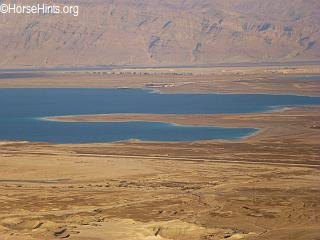
Dead Sea and the Masada
Dead Sea/Salt Sea: The lowest point on earth at 1,365 feet below sea level--take a dip. The Dead Sea is an endorheic lake located in the Jordan Rift Valley, a geographic feature formed by the Dead Sea Transform (DST). This left lateral-moving transform fault lies along the tectonic plate boundary between the African Plate and the Arabian Plate. It runs between the East Anatolian Fault zone in Turkey and the northern end of the Red Sea Rift offshore of the southern tip of Sinai.
The Jordan River is the only major water source flowing into the Dead Sea, although there are small perennial springs under and around the Dead Sea, forming pools and quicksand pits along the edges. There are no outlet streams.
Rainfall is scarcely 100 mm (4 in) per year in the northern part of the Dead Sea and barely 50 mm (2 in) in the southern part. The Dead Sea zone's aridity is due to the rain shadow effect of the Judean Hills. The highlands east of the Dead Sea receive more rainfall than the Dead Sea itself. To the west of the Dead Sea, the Judean Hills rise less steeply and are much lower than the mountains to the east. Along the southwestern side of the lake is a 210 m (700 ft) tall halite formation called "Mount Sodom".
In recent decades, the Dead Sea has been rapidly shrinking because of diversion of incoming water from the Jordan River to the north. The southern end is fed by a canal maintained by the Dead Sea Works, a company that converts the sea's raw materials. From a depression of 395 m (1,296 ft) below sea level in 1970 it fell 22 m (72 ft) to 418 m (1,371 ft) below sea level in 2006, reaching a drop rate of 1 m (3 ft) per year. As the water level decreases, the characteristics of the Sea and surrounding region may substantially change.
Dead Sea shrinking The Dead Sea level drop has been followed by a ground water level drop, causing brines that used to occupy underground layers near the shoreline to be flushed out by freshwater. This is believed to be the cause of the recent appearance of large sinkholes along the western shore-incoming freshwater dissolves salt layers, rapidly creating subsurface cavities that subsequently collapse to form these sinkholes.
Mineral Beach In Mineral Beach, on a well-tended shore of the Dead Sea, are two little pools: a fresh-water pool for small children, and a sulphur-water pool with a fixed temperature of 39 ºC whose water arrives from an adjacent spring. On the shore there are open-sided, chill-out style, shelter pavilions from around the world, and plastic chairs. Right on the shoreline is natural mud - when spread on your body, it stimulates blood circulation, strengthens hair roots, and renews skin cells.
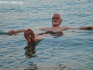 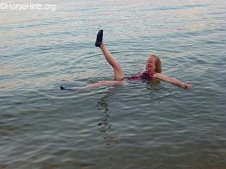
Bill floating (left), Debbie floating (right) It is almost like being a turtle on its back. Trying to flip over is really difficult. You do not have to wade very far--just above your knees to float!
Masada

Masada Tram Masada: "Masada is an ancient fortification in the Southern District of Israel situated on top of an isolated rock plateau (akin to a mesa) on the eastern edge of the Judaean Desert, overlooking the Dead Sea. Herod the Great built palaces for himself on the mountain and fortified Masada between 37 and 31 BCE. The Siege of Masada by troops of the Roman Empire towards the end of the First Jewish-Roman War ended in the mass suicide of the 960 Jewish rebels....
The site of Masada was identified in 1842 and extensively excavated between 1963 and 1965 by an expedition led by Israeli archaeologist Yigael Yadin. Due to the remoteness from human habitation and its arid environment, the site remained largely untouched by humans or nature for two millennia. The Roman attack ramp still stands on the western side and can be climbed on foot. Many of the ancient buildings have been restored from their remains, as have the wall-paintings of Herod's two main palaces, and the Roman-style bathhouses that he built. The synagogue, storehouses, and houses of the Jewish rebels have also been identified and restored. The meter-high circumvallation wall that the Romans built around Masada can be seen, together with eleven barracks for the Roman soldiers just outside this wall. Water cisterns two-thirds of the way up the cliff drain the nearby wadis by an elaborate system of channels, which explains how the rebels managed to conserve enough water for such a long time.
Inside the synagogue, an ostracon bearing the inscription me'aser cohen (tithe for the priest) was found, as were fragments of two scrolls; parts of Deuteronomy 33-34 and parts of Ezekiel 35-38 (including the vision of the 'dry bones'), found hidden in pits dug under the floor of a small room built inside the synagogue. In other loci fragments were found of the books of Genesis, Leviticus, Psalms, and Sirach, as well as of the Songs of the Sabbath Sacrifice.
In the area in front of the northern palace, eleven small ostraca were recovered, each bearing a single name. One reads 'ben Yair' and could be short for Eleazar ben Ya'ir, the commander of the fortress. It has been suggested that the other ten names are those of the men chosen by lot to kill the others and then themselves, as recounted by Josephus.
The skeletal remains of 28 people were unearthed at Masada. The remains of a male 20-22 years of age, a female 17-18 and a child approximately 12 years old were found in the palace. The remains of two men and a full head of hair with braids belonging to a woman were also found in the bath house. Forensic analysis showed the hair had been cut from the woman's head with a sharp instrument while she was still alive (a Jewish practice for captured women) while the braids indicated that she was married. Based on the evidence, anthropologist Joe Zias believes the remains may have been Romans whom the rebels captured when they seized the garrison.
The sparse remains of another 24 people were found in a cave at the base of the cliff. Although the excavator Yigal Yadin was unsure of their ethnicity, the Rabbinical establishment concluded that they were remains of the Jewish defenders, and in July 1969 they were reburied as Jews in a state ceremony. Carbon dating of textiles found with the remains in the cave indicate they are contemporaneous with the period of the Revolt and pig bones were also present (occasionally occurring for Roman burials due to pig sacrifices); this indicates that the remains may belong to non-Jewish Roman soldiers or civilians who occupied the site before or after the siege. Zias also questioned whether there were so many as 24 individuals present, since only 4% of that number of bones was recovered.
According to Shaye Cohen, archaeology shows that Josephus' account is 'incomplete and inaccurate'. Josephus only writes of one palace, archaeology reveals two, his description of the northern palace contains several inaccuracies, and he gives exaggerated figures for the height of the walls and towers. Josephus' account is contradicted by the 'skeletons in the cave, and the numerous separate fires'. According to Kenneth Atkinson, there is no 'archaeological evidence that Masada's defenders committed mass suicide.'
The remnants of a Byzantine church dating from the 5th and 6th centuries have also been excavated on the top of Masada. The Masada story was the inspiration for the 'Masada plan' devised by the British during the Mandate era. The plan was to man defensive positions on Mount Carmel with Palmach fighters, in order to stop Erwin Rommel's expected drive through the region in 1942. The plan was abandoned following Rommel's defeat at El Alamein.
The Chief of Staff of the Israel Defense Forces (IDF), Moshe Dayan, initiated the practice of holding the swearing-in ceremony of Israeli Armoured Corps soldiers who had completed their Tironut (IDF basic training), on top of Masada. The ceremony ended with the declaration: 'Masada shall not fall again.' The soldiers climbed the Snake Path at night and were sworn in with torches lighting the background. This ceremony is now held at Latrun, outside Jerusalem.
Masada was declared a UNESCO World Heritage Site in 2001. An audiovisual light show is presented nightly on the western side of the mountain (access by car from the Arad road or by foot, down the mountain via the Roman ramp path). While a hike up the Snake Path on the eastern side of the mountain (access via the Dead Sea Highway) is considered part of the 'Masada experience,' a cable car operates at the site for those who wish to avoid the physical exertion. ..."
Masada
A genizah plural: genizot or genizoth or genizahs) is a storage area in a Jewish synagogue or cemetery designated for the temporary storage of worn-out Hebrew-language books and papers on religious topics prior to proper cemetery burial.
"...Genizot are temporary repositories designated for the storage of worn-out Hebrew-language books and papers on religious topics prior to proper cemetery burial, it being forbidden to throw away writings containing the name of God (even personal letters and legal contracts could open with an invocation of God). In practice, genizot have also contained writings of a secular nature, with or without the customary opening invocation, and also contained writings in other Jewish languages that use the Hebrew alphabet (Judeo-Arabic, Judeo-Persian, Judeo-Spanish, Yiddish). Genizot are typically found in the attic or basement of a synagogue, but can also be in walls or buried underground. They may also be located in cemeteries.
The contents of genizot are periodically gathered solemnly and then buried in the cemetery or 'bet ?ayyim.' Synagogues in Jerusalem buried the contents of their genizot every seventh year, as well as during a year of drought, believing that this would bring rain. This custom is associated with the far older practice of burying a great or good man with a 'sefer' (either a book of the Tanakh, or the Mishnah, the Talmud, or any work of rabbinic literature) which has become 'pasul' (unfit for use through illegibility or old age). The tradition of paper-interment is known to have been practiced in Morocco, Algiers, Turkey, and Egypt. ..."

Masada where documents of a sacred nature were reviewed for retirement. (Inn) Museum of the Good Samaritan: "The museum at the Good Samaritan Inn archaeological site by Ma'ale Adumim is the only mosaic museum in the country and one of only three in the world. Mosaics and other artifacts unearthed in Judea, Samaria and Gaza are on display at the museum. Some of the mosaics on display have been removed from various sites to protect them from harm, while others are reconstructions. Work on the mosaics, to prepare them for the public eye, has taken many years during which skilled professionals excavated the mosaics, preserved them and, where necessary, reconstructed them. During the preservation process, some mosaics were cast in natural materials such as lime, sand or cement as they would have been in ancient times. ..."
(Inn) Museum of the Good Samaritan
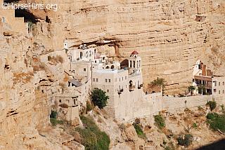
St. George Monastery: "...St. George's Monastery began in the fourth century with a few monks who sought the desert experiences of the prophets, John the Baptist and Jesus, and settled around a cave where they believed Elijah was fed by ravens (1 Kings 17:5-6). The sixth-century cliff-hanging complex, with its ancient chapel and gardens, is still inhabited by a few Greek Orthodox monks. It is reached by a pedestrian bridge across the Kelt River canyon, which many imagine to be Psalm 23's Valley of the Shadow, and where shepherds still watch over their flocks, just as Ezekiel 34 and John 10:1-16 describe. The valley parallels the old Roman road to Jericho, the backdrop for the parable of the Good Samaritan (Luke 10:29-37).
Tomb of Prophet Moses:
Q'Asir Al-Uahud Baptism Sight: "The baptismal site on the banks of the Jordan River, Qasr al-Yahud, is the site where according to tradition, Jesus was baptized by John the Baptist. Christian tradition marks this site as the place of the 'spiritual birth' of Jesus as opposed to his physical birth in Bethlehem. As such, the baptismal site is of great sacred significance - the third holiest site in the Christian world (after the Church of the Nativity in Bethlehem and the Church of the Holy Sepulchre in Jerusalem). ..."
Rachel's Tomb: "...Following the Six Day War in 1967, Israel gained control of the West Bank, which included the tomb. The tomb was placed under Israeli military administration. Some time after the capture, Islamic crescents, inscribed into the rooms of the structure, were erased. Muslims claim that they were prevented from using the mosque, although they were allowed to use the cemetery for a while. Prime minister Levi Eshkol instructed that the tomb be included within the new expanded municipal borders of Jerusalem, but citing security concerns, Moshe Dayan decided not to include it within the territory that was annexed to Jerusalem. Starting in 1993, Muslims were barred from using the cemetery . According to Bethlehem University, [a]ccess to Rachel's Tomb is now restricted to tourists entering from Israel.'
Oslo Accords and aftermath (1995-2002)
Following the Oslo accords, the Israeli-Palestinian Interim Agreement was signed on September 28, 1995, placing Rachel's Tomb in Area C under Israeli jurisdiction. Although Israel's first draft had placed Rachel's Tomb, which is situated 460 metres from the municipal border of Jerusalem, in Area A under PA jurisdiction, pressure was exerted by religious parties in Israel at the time of negotiations (1994-95) in order to keep the religious site under Israeli control.
On December 1, 1995, Bethlehem, with the exception of the tomb enclave, passed under the full control of the Palestinian Authority. Jews could reach it in bulletproof vehicles under military supervision. In 1996 Israel began an 18-month fortification of the site at a cost of $2m. It included a 13 foot high wall and adjacent military post. In response, Palestinians said that 'the Tomb of Rachel was on Islamic land' and that the structure was in fact a mosque built at the time of the Arab conquest in honour of Bilal ibn Rabah, an Ethiopian known in Islamic history as the first muezzin.
After an attack on Joseph's Tomb and its subsequent takeover by Arabs, hundreds of residents of Bethlehem and the Aida refugee camp, led by the Palestinian Authority-appointed governor of Bethlehem, Muhammad Rashad al-Jabari, attacked Rachel's Tomb. They set the scaffolding that had been erected around it on fire and tried to break in. The IDF dispersed the mob with gunfire and stun grenades, and dozens were wounded. In the following years, the Israeli-controlled site became a flashpoint between young Palestinians who hurled stones, bottles and firebombs and IDF troops, who responded with tear gas and rubber bullets.
At the end of 2000, when the second intifada broke out, the tomb came under attack for 41 days. Fatah operatives and members of the Palestinian security services who were responsible for curbing militant activity against Israelis actively participated in it. In May 2001, fifty Jews found themselves trapped inside by a firefight between the IDF and Palestinian Authority gunmen. In March 2002 the IDF returned to Bethlehem as part of Operation Defensive Shield and remained there for an extended period of time. In September 2002, the tomb was incorporated on the Israeli side of the West Bank barrier and surrounded by a concrete wall and watchtowers.
In February 2005, the Israel Supreme Court rejected a Palestinian appeal to change the route of the security fence in the region of the tomb. Israeli construction destroyed the Palestinian neighborhood of Qubbet Rahil. Israel also declared the area to be a part of Jerusalem. In February 2010, Israeli Prime Minister Netanyahu announced that the tomb would become a part of the national Jewish heritage sites rehabilitation plan. The decision was opposed by the Palestinian Authority, who saw it as a political decision associated with Israel's settlement project. The UN's special coordinator for the Middle East, Robert Serry, issued a statement of concern over the move, saying that the site is in Palestinian territory and has significance in both Judaism and Islam. The Jordanian government said that the move would derail peace efforts in the Middle East and condemned 'unilateral Israeli measures which affect holy places and offend sentiments of Muslims throughout the world'. UNESCO urged Israel to remove the site from its heritage list, stating that it was 'an integral part of the occupied Palestinian territories'. A resolution was passed at UNESCO that acknowledged both the Jewish and Islamic significance of the site, describing the site as both Bilal ibn Rabah Mosque and as Rachel's Tomb. The resolution passed with 44 countries supporting it, twelve countries abstaining, and only the United States voting to oppose. An article written by Nadav Shargai of the Jerusalem Center for Public Affairs, published in the Jerusalem Post criticized UNESCO, arguing that the site was not a mosque and that the move was politically motivated to disenfranchise Israel and Jewish religious traditions. Also writing in the Jerusalem Post, Larry Derfner, defended the UNESCO position. He pointed out that UNESCO had explicitly recognized the Jewish connection to the site, having only denounced Israeli claims of sovereignty, while also acknowledging the Islamic and Christian significance of the site. The Israeli Prime Minister's Office criticised the resolution, claiming that: 'the attempt to detach the Nation of Israel from its heritage is absurd... If the nearly 4,000-year-old burial sites of the Patriarchs and Matriarchs of the Jewish Nation - Abraham, Isaac, Jacob, Sarah, Rebecca, Rachel and Leah - are not part of its culture and tradition, then what is a national cultural site?..."

Tomb of Raakel (Rachel) near Bethlehem Mary's Spring
The video below is of Israel in the warmer climates. We were in Israel in the winter months and, of course, it looked much different. In fact, there was an historical snowfall of 20 inches in Jerusalem while we were visiting. That was exciting! Even in the winter months we could see that much of Israel was a productive agricultural oasis.
|